LAPAN will cooperate with the Provincial Government of Jakarta City on aeronautics and science and technology to support development projects.
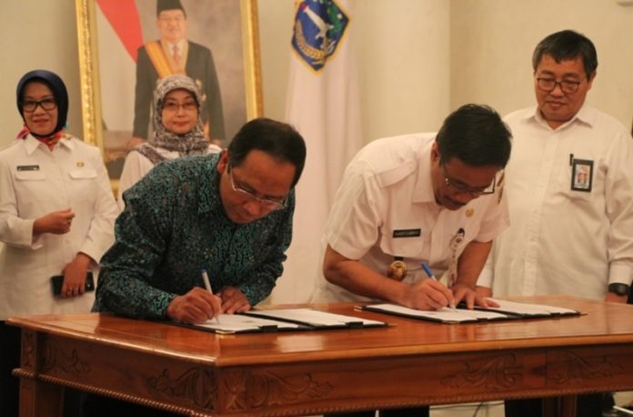
The draft of agreement with both parties was signed by the Head of LAPAN, Prof. Dr. Thomas Djamaluddin and the Governor of DKI Jakarta (Special Capital City District of Jakarta), Djarot S. Hidayat. The ceremonial signing took place at the City Hall of DKI Jakarta, Wednesday (31/05).
On the same occasion, a cooperation agreement between LAPAN and the Regional Development Planning Board (Bappeda) of the Provincial Government of DKI Jakarta was signed.
The aim is to use remote sensing data and aeronautical technology to support development planning.
The agreement was signed by Jakarta Provincial Secretary, Saefullah and Head of Bureau of Cooperation, Public Relations and Public Affairs, Christianus R. Dewanto. An additional agreement was signed between the Provincial Government of DKI Jakarta and the Central Bureau of Statistics (BPS).
In his speech, the Head of LAPAN explained the potential of LAPAN that can be utilized by DKI Jakarta Provincial Government. LAPAN-treated Satellite Image data can be used for natural resource monitoring, such as Fish Potential Zone (ZPPI), environmental conditions such as Green Open Space monitoring (RTH), possible sedimentation monitoring and other environmental issues.
Satellite image data can also monitor the development of Jakarta. “So far, LAPAN has contributed to support flood monitoring in the Jakarta area using LAPAN Surveillance UAV (LSU). This unmanned aircraft can monitor from the air at an altitude below the cloud cover, which has been a constraint to the acquisition of satellite images,” he said.
He also emphasised LAPAN’s four major fields of R&D competency, which are: space and atmospheric science, remote sensing, aviation and space technology, and the study of aviation and space policies.
“Hopefully with the establishment of this cooperation, LAPAN can contribute to providing benefits to encourage development in the region as a whole,” expressed Thomas.
Djarot welcomed the cooperation between LAPAN and BPS. “BPS will support the exploration of potential human resources [on land], while LAPAN will monitor environmental resources from the air,” he explained.
BPS, a national body, studies population data, such as census, survey, environmental conditions, export-import data, health, economy, etc.
LAPAN’s technology would help in the field of remote sensing, supporting the monitoring of the number of open green spaces in Jakarta, for example.
Sensor data will also prove to be helpful in monitoring fish population in the sea, with which at least 2400 fishermen in DKI can be deployed to rich fishing grounds.
Satellite image data will also prove useful in identifying the potential for pollution, disaster, and possible fire hazards.
Djarot revealed: “The problem is, we often ignore valid data – the ‘Copy-paste’ culture should be abandoned. We should start by using the latest, valid data so that it can support the work effectively and efficiently,” he explained.
Djarot expects that LAPAN’s R&D technology can be used to monitor the movement of vehicles in and out of Jakarta, in order to manage transportation routes in Jakarta which are getting increasingly crowded. He finally reiterated that the synergy that was being built up could support the development planning of Jakarta City in various sectors.


