Tunisia’s Ministry of Culture recently unveiled that Chinese scientists have uncovered 10 ancient Roman archaeological remains in Tunisia using China’s remote sensing satellites and related space-based technologies.
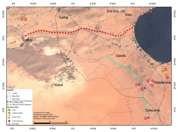
These sites, located in Gafsa, Tataouine and Medenine, include two Roman forts, three giant water basins, an irrigation system, a cemetery and three fortified Roman military roads lined with walls and watchtowers.
These represent the first archaeological sites outside of China that Chinese scientists have discovered using remote sensing, and were made using a combination of remote sensing data, satellite navigation systems, literature analysis and field research.
Said Wang Xingyuan, the RADI leader of the project, “These archeological remains reflect the military defense system of the southern Roman Empire.”
These efforts are part of China’s Belt and Road Initiative, and involved scientists from China, Tunisia, Italy and Pakistan. The Tunisian project began in 2016, when China’s Institute of Remote Sensing and Digital Earth (RADI), which is part of the Chinese Academy of Sciences (CAS), began processing and analyzing remote sensing data. This was followed by archaeological expeditions to the sites for verification, with the discoveries having been confirmed in April 2017.
At a press conference, Tunisia’s Culture Minister Mohamed Zine el Abidine said that Tunisia welcomes multi-disciplinary scientific cooperation and hopes that the work will continue.


